Bob Embleton
Photo: Bob Embleton CC BY-SA 2.0

Rosslare Strand

Rating: 0.0/5 (0 votes)

  • Water temp(satellite):
  • 14.3°C
  • 2024-10-14

Rosslare Strand is located in Wexford. During the bathing season, a life guard is on duty. There are toilets and a parking spot nearby. Dogs must be kept on a leash at all times. People with disabilities can access the beach. Beach wheelchair is available. Contact Centra Shop, Strand Road, Rosslare 053 9173060. June to August inclusive.Bus, Train
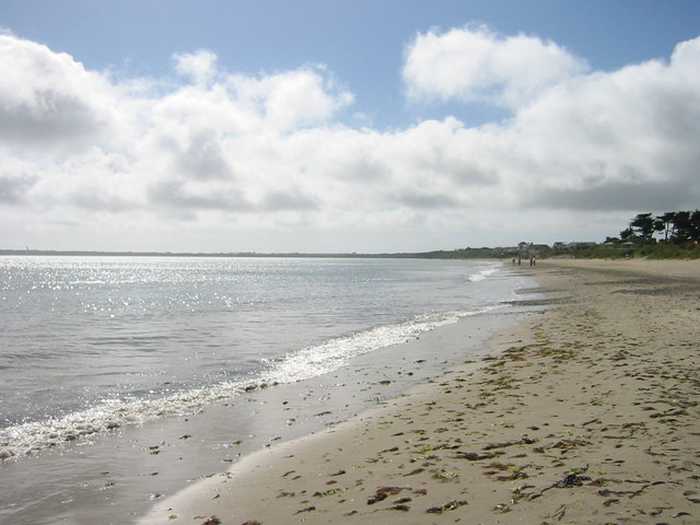
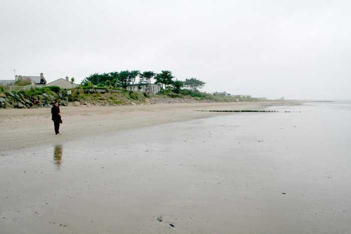
Rosslare Strand is an urban beach with fine, soft, windblown sand and a gentle slope. The sand dunes to the west are narrow and vegetation is scarce in the waters. The Wexford Wildfowl Reserve is located nearby, offering stunning views of the southeast coast of Ireland. The beach is a popular fishing spot, as well as a limited area for surfing, windsurfing, and canoeing. The bathing area spans 0.5 km and covers 0.1 km².
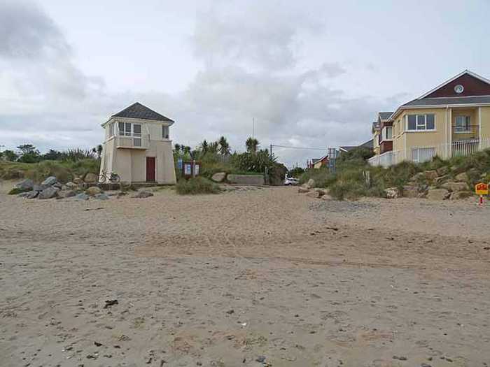
Activities;Rosslare Strand beach is also a popular fishing spot. The beach is also used by a limited number of surfers, windsurfers and canoeists. Facilities;Public car parking, town street parking and car park with 2 disabled spaces. There is a viewing point at the beach which is accessed by wooden walkway from the car park. Male, Female and disabled toilet available all year. Universal key is required to gain access to the accessible toilets. Outdoor shower available. Life guards are on duty on site during summer months. There is a children’s play ground near the beach.
Location;The beach at Rosslare Strand (Irish: Ros Láir, meaning "the middle peninsula") comprises of sand and stone running the length of the southern peninsula which protrudes into Wexford Harbour. The main beach is accessed by various walkways and its main access point is from the main car park. The beach is segmented by a series of main breakwaters which were designed to retain sandy deposits along the beach. Rosslare has been a tourist resort for at least 100 years. Rosslare is commonly known in Ireland as being in the "Sunny South-East", and in 1959 Rosslare recorded 1,996.4 hours of sunshine, the highest recorded in Ireland. Rosslare receives 300 hours more sunshine each year than the average place in Ireland. The long sandy strand is a Blue Flag beach so it attracts swimmers and families, while there are a number of good golf courses in the vicinity. The Dublin to Rosslare Europort railway passes through the village. Rosslare has good hotels and restaurants. A long sand spit stretching north from Rosslare separates Wexford Harbour from the Irish Sea. Until the early 1920s, this spit stretched for over 6 km north of the village, almost touching the Raven Point and giving a very narrow mouth to Wexford Harbour. At the end of the spit was a small fort called Rosslare Fort. In the winter of 1924-25 a storm breached the spit and it was gradually washed away. The fort was abandoned and now all that is left is an island at low tide. Most maps of Ireland, however, still show the long spit of sand. In the 1990’s, a major beach replenishment/stabilization project was carried out, involving the construction of 13 rock armour groynes and the importation of sand from offshore banks and its deposition along the length of the spit to the north of the identified bathing area. Extent;The bathing area is approximately 0.5 km long. The bathing water is approximately 0.1 km2 in area.
;A safe urban fine-sand beach, Rosslare Strand has had Blue Flag status since 2004. The sand type is soft and wind blown. Deposition offshore into a series of sand-banks offers protection to the beach.

Weather forecast
Rosslare Strand on the map
Report water temp:

Photos near Rosslare Strand

Rob Motha
Photo: Rob Motha CC BY-SA 2.0
Oliver Dixon
Photo: Oliver Dixon CC BY-SA 2.0
Do you have a nice picture from Rosslare Strand?
By uploading an image, you certify that you own the image and that it may be displayed on beachguideireland.com

Reviews of Rosslare Strand

No reviews of Rosslare Strand yet...
Please help the next visitor by writing a few lines about the beach, are there toilets? Is it shallow? Is there a jetty or maybe a kiosk?
What do you think of the beach?

Beaches close to Rosslare Strand

St Helens Bay ⟼ 6.2 km away
St. Helens Bay Beach, located south of Rosslare Euro Port, is a tranquil and sheltered beach. There is convenient car parking available directly beside the beach.
Carne ⟼ 8.5 km away
Carne is a sandy beach located near Carne pier, facing east towards the Irish Sea with a dune system situated to its west.
Culletons Gap ⟼ 11.9 km away
Culleton's Gap is situated one mile from Curracloe Co Wexford, forming part of the sandy Curracloe stretch overlooking Wexford Bay and the Irish Sea towards the east. It shares borders with Raven Nature Reserve, the North Slob Land and Wild Fowl Reserve towards the west.
Curracloe ⟼ 12.9 km away
Curracloe is a serene, rural beach with fine, soft, wind-blown sand and gentle slopes. It features wooden walkways that sometimes get covered by sand. Its sand dunes extend between 100m to 300m westward, while also being part of The Raven Special Protection Area that's crucial for bird conservation and is included in the Wexford Slobs and Harbour complex. It's a popular fishing spot and is sometimes used by a small number of surfers, windsurfers, and canoeists. The bathing area extends about 1 km in length and covers 0.2km².
Ballyhealy ⟼ 13.4 km away
Ballyhealy beach is a shallow sandy beach located towards the east of Kilmore Quay in Co. Wexford.
Ballinesker ⟼ 14.1 km away
Ballinesker is a serene rural beach with fine soft sand and a gentle slope. Wooden walkways may be covered with sand due to the wind. The beach is protected by sand-banks and sand dunes extend up to 70m behind the beach. However, there is no significant vegetation growth in the waters near the beach. It's popular for fishing and used by few surfers, windsurfers, and canoeists. The bathing area spans around 1 km with an area of 0.2 km².
Kilmore Quay Small Beach ⟼ 17.6 km away
Kilmore Quay village has a small southerly-facing beach located just east of the fishing harbor within the Saltee Islands SAC.
Cullenstown ⟼ 23.7 km away
Cullenstown beach faces south and is a sandy beach located on the western edge of the River Muck's entrance to the sea.
Morriscastle ⟼ 28.5 km away
Morriscastle beach is a serene and rural sandy beach with soft, wind-blown sand and a gentle slope. Behind the beach, the sand dunes stretch up to 100m westward. The bathing area, which spans 1.0 km in length and 0.2km² in area, falls within the conservation region of Kilmuckridge-Tinaberna sand hills, which supports unique dune habitats and thus designates Morriscastle beach as an SAC. There is no significant vegetation in the water near the beach.
Grange ⟼ 31.3 km away
Grange is a remote beach near Fethard on Sea located on the Hook Head peninsula. Parking is available on the roadside.
Beach Guide Ireland Source for water samples and information: the Environmental Protection Agency, users of the site and local municipalities.
Source for weather data: Met Éireann© (CC BY 4.0) Disclaimer: Met Éireann does not accept any liability whatsoever for any error or omission in the data, their availability, or for any loss or damage arising from their use.
Source of satellite-read water temperature: Copernicus Sentinel satellite data from the European Space Agency.