Hugh Chappell
Photo: Hugh Chappell CC BY-SA 2.0

Morriscastle

Rating: 0.0/5 (0 votes)

  • Water temp(satellite):
  • 14.2°C
  • 2024-10-14

Morriscastle is a beach in the county of Wexford. Life guard is present at bathing season. Toilets and parking lot near the beach. Dogs must be kept on a leash. Enhanced accessibility for disabled persons. Beach wheelchair is available. Contact Lawler's Shop 053-9130334 June to Aug inclusive.
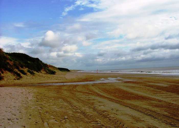
Morriscastle beach is a serene and rural sandy beach with soft, wind-blown sand and a gentle slope. Behind the beach, the sand dunes stretch up to 100m westward. The bathing area, which spans 1.0 km in length and 0.2km² in area, falls within the conservation region of Kilmuckridge-Tinaberna sand hills, which supports unique dune habitats and thus designates Morriscastle beach as an SAC. There is no significant vegetation in the water near the beach.
Activities;Morriscastle Beach and its continuation Tinaberna are extremely popular venues with shore anglers and are regularly used for competitions. One of the reasons for these venues' popularity is their ability to produce specimen sized fish. Species encountered include bass, tope, smoothhound, bullhuss, rock salmon, spurdog, ray, flounder and dab. Night fishing produces the best results. Facilities;On-road parking and a car park is available with 2 disabled spaces. Access to the beach is from the car park via a wooden sleeper walkway. Access for the disabled can be difficult due to wind blown sand on walkway which slopes slightly to sea. There is a local shop adjacent to the car park which also sells hot food. Male, Female and disabled toilet available. Opened Bank holiday weekends October to May. All 7 days/week May – October Opening hours 8am - 9pm. Universal key is required to gain access to the accessible toilets. Outside cold shower available. Life guards are on duty on site during summer months.
Location;The beach at Morriscastle is situated on the east coast of County Wexford facing the Irish Sea. It is 3 km from the village of Kilmuckridge and 25 km north of Wexford Town. Morriscastle beach is a popular venue for families and is a rural fine sandy beach which is part of a long sandy coastal strip bordered to the west by a sand dune system. Morriscastle Beach has had Blue Flag status since 2008 and it is claimed to be the longest beach in Ireland and is known locally as the ‘Golden Mile’. The area is important from a nature point of view with a Special Area of Conservation – Kilmuckridge / Tinaberna Sand hills to the South. The Wexford Coastal Pathway passes through Morriscastle on its 221km journey. The best access is via the R742 and Kilmuckridge Village. The beach can then be reached by a 150 metre walk from the car park onto the strand. The beach is a very popular for bathing with locals and visitors. Morriscastle Beach is an extremely popular venue for shore anglers and is regularly used for competitions. One of the reasons for this venue's popularity is its ability to produce specimen sized fish. Species encountered include bass, tope, smoothhound, bullhuss, dogfish, spurdog, ray, flounder and dab. Extent;The bathing area is approximately 1.0 km long. The bathing water is approximately 0.2 km2 in area.
;A safe rural peaceful fine-sand beach, Morriscastle has had Blue Flag status since 2008. The sand type is soft and wind blown and often covers the wooden walkways. Deposition offshore into a series of sand-banks offers protection to the beach.

Weather forecast
Morriscastle on the map
Report water temp:

Photos near Morriscastle

Do you have a nice picture from Morriscastle?
By uploading an image, you certify that you own the image and that it may be displayed on beachguideireland.com

Reviews of Morriscastle

No reviews of Morriscastle yet...
Please help the next visitor by writing a few lines about the beach, are there toilets? Is it shallow? Is there a jetty or maybe a kiosk?
What do you think of the beach?

Beaches close to Morriscastle

Old Bawn ⟼ 4.5 km away
Old Bawn Beach is a 3km long sandy coastline located in County Wexford, 5km southeast of Ballygarrett village. It is part of the Cahore Polders and Dunes National Heritage Area and faces east towards the Irish Sea, with a line of sand dunes on its western border.
Cahore ⟼ 5.6 km away
Located adjacent to the rural village of Cahore, in Co. Wexford, Cahore Beach is a pebbled beach stretching for approximately 500m. It offers stunning views of the Irish Sea and is complemented by a pier and a car park for visitors' convenience.
Courtown, North Beach ⟼ 14.9 km away
Courtown North beach is an urban fine-sand beach with gentle slopes and backed by well-vegetated dunes. The beach has a viewing area and a designated spot for jet skis. It is also used by a limited number of surfers, windsurfers, and canoeists. The bathing area spans 0.5 km in length and covers approximately 0.1 km². There is no significant vegetation growing in the waters off the beach.
Ballinesker ⟼ 15 km away
Ballinesker is a serene rural beach with fine soft sand and a gentle slope. Wooden walkways may be covered with sand due to the wind. The beach is protected by sand-banks and sand dunes extend up to 70m behind the beach. However, there is no significant vegetation growth in the waters near the beach. It's popular for fishing and used by few surfers, windsurfers, and canoeists. The bathing area spans around 1 km with an area of 0.2 km².
Curracloe ⟼ 16.3 km away
Curracloe is a serene, rural beach with fine, soft, wind-blown sand and gentle slopes. It features wooden walkways that sometimes get covered by sand. Its sand dunes extend between 100m to 300m westward, while also being part of The Raven Special Protection Area that's crucial for bird conservation and is included in the Wexford Slobs and Harbour complex. It's a popular fishing spot and is sometimes used by a small number of surfers, windsurfers, and canoeists. The bathing area extends about 1 km in length and covers 0.2km².
Culletons Gap ⟼ 17.2 km away
Culleton's Gap is situated one mile from Curracloe Co Wexford, forming part of the sandy Curracloe stretch overlooking Wexford Bay and the Irish Sea towards the east. It shares borders with Raven Nature Reserve, the North Slob Land and Wild Fowl Reserve towards the west.
Ballymoney, North Beach ⟼ 18.7 km away
Ballymoney North beach is a tranquil rural area with soft-medium sand and gentle slope. Offshore deposition forms sand-banks that protect the beach. Sand dunes stretch 50-100m westward, part of the Natural Heritage Area, favored for fishing. The bathing zone extends about 300m and occupies 0.06 km².
Clogga ⟼ 28.3 km away
Clogga Beach is a sandy beach that is bordered by cliffs and rocks, leading to shallow and crystal-clear waters. The cliffs and Arklow Rock support nesting birds and are part of the proposed Natural Heritage Area (pNHA001745) known as Arklow Rock-Askintinny.
Rosslare Strand ⟼ 28.5 km away
Rosslare Strand is an urban beach with fine, soft, windblown sand and a gentle slope. The sand dunes to the west are narrow and vegetation is scarce in the waters. The Wexford Wildfowl Reserve is located nearby, offering stunning views of the southeast coast of Ireland. The beach is a popular fishing spot, as well as a limited area for surfing, windsurfing, and canoeing. The bathing area spans 0.5 km and covers 0.1 km².
The Cove Arklow ⟼ 30.3 km away
The Arklow Rock beach is a small, sandy shore, protected by rock armour and a breakwater to the north. It is submerged during high tide and can only be accessed at one's own risk via a steep and uneven track located at the end of the breakwater. This path requires surefootedness.
Beach Guide Ireland Source for water samples and information: the Environmental Protection Agency, users of the site and local municipalities.
Source for weather data: Met Éireann© (CC BY 4.0) Disclaimer: Met Éireann does not accept any liability whatsoever for any error or omission in the data, their availability, or for any loss or damage arising from their use.
Source of satellite-read water temperature: Copernicus Sentinel satellite data from the European Space Agency.