P L Chadwick 
Photo: P L Chadwick  CC BY-SA 2.0

Courtown, North Beach

Rating: 0.0/5 (0 votes)

  • Water temp(satellite):
  • 14.4°C
  • 2024-10-14

Courtown, North Beach is a beach in the county of Wexford. During the bathing season, a lifeguard is on duty. The beach is equipped with toilets and a parking lot. Dogs must be kept on a leash at all times. Improved accessibility for people with disabilities. Beach wheelchair is available. Not available for 2019.Bus
Courtown North beach is an urban fine-sand beach with gentle slopes and backed by well-vegetated dunes. The beach has a viewing area and a designated spot for jet skis. It is also used by a limited number of surfers, windsurfers, and canoeists. The bathing area spans 0.5 km in length and covers approximately 0.1 km². There is no significant vegetation growing in the waters off the beach.
Activities;There is a designated area for jet skis. The beach is also used by a limited number of surfers, windsurfers and canoeists. There is also a slipway for launching and recovery of pleasure craft in the adjacent harbour. Facilities;There is a regular bus service and trains from Connolly Station, Dublin to Gorey. Courtown and North Wexford are just 45 minutes from Rosslare Europort by car. There are extensive public car parking spaces, including disabled spaces, available both in the town and adjacent to the beach. Access to the beach is wooden ramp walkway with 1 rest area. Male, Female and disabled toilets are available in the town and opened all year round. Universal key is required to gain access to the accessible toilets. There is also a wheelchair accessible viewing area. Life guards are on duty during summer months.
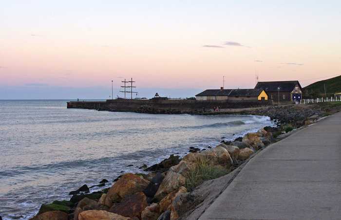
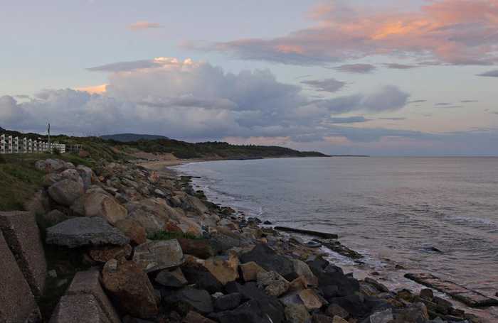
Location;Courtown is approximately 7 km South East of Gorey town. Courtown Beach is one of Wexford’s most important tourist and amenity areas. The beach is narrow, particularly at its southern end and is made up of fine/medium sand on top of mixed sand/shingle material. The beach is backed by dunes which are generally well vegetated although species are more characteristic of woodland scrub than coastal dunes. Stone toe protection and rock armour now extend for some 750m metres north of Courtown Harbour. Work on the construction of Courtown Harbour commenced in 1828. However the construction work was difficult and the harbour did not come into use until about 1837. The North Beach has been a firm favourite with tourists for many years and today is extremely popular with families, walkers, water sports and sun seekers. The beach has a borough along side it which contains ideal spots for picnics and lovely woodlands for walking. The South Beach of Courtown is a much smaller beach than the north beach, but is close by so also benefits from the village amenities. It is a quieter and more tranquil beach but is not however suitable for swimming. Facing the Irish Sea, Courtown Beach is a fine-sand Blue Flag beach (2010) and has extensive coastal protection works all along the boundary between the dunes/woodland and the beach itself. The village of Courtown is located around a harbour and canal system. The beach itself is relatively narrow around the main access points due to ongoing coastal erosion but expands in width the further north you travel. Extent;The bathing area is approximately 0.5 km long. The bathing water is approximately 0.1 km2in area.
A safe urban fine-sand beach, Courtown North Beach has had Blue Flag status since 2004. The sand type is fine and wind blown. The beach is accessed from ample car parking areas by a wooden ramp walkway with 1 rest point. The beach also has a disabled accessible viewing area.

Weather forecast
Courtown, North Beach on the map
Report water temp:

Photos near Courtown, North Beach

P L Chadwick 
Photo: P L Chadwick  CC BY-SA 2.0
Do you have a nice picture from Courtown, North Beach?
By uploading an image, you certify that you own the image and that it may be displayed on beachguideireland.com

Reviews of Courtown, North Beach

No reviews of Courtown, North Beach yet...
Please help the next visitor by writing a few lines about the beach, are there toilets? Is it shallow? Is there a jetty or maybe a kiosk?
What do you think of the beach?

Beaches close to Courtown, North Beach

Ballymoney, North Beach ⟼ 4 km away
Ballymoney North beach is a tranquil rural area with soft-medium sand and gentle slope. Offshore deposition forms sand-banks that protect the beach. Sand dunes stretch 50-100m westward, part of the Natural Heritage Area, favored for fishing. The bathing zone extends about 300m and occupies 0.06 km².
Cahore ⟼ 10.2 km away
Located adjacent to the rural village of Cahore, in Co. Wexford, Cahore Beach is a pebbled beach stretching for approximately 500m. It offers stunning views of the Irish Sea and is complemented by a pier and a car park for visitors' convenience.
Old Bawn ⟼ 11.2 km away
Old Bawn Beach is a 3km long sandy coastline located in County Wexford, 5km southeast of Ballygarrett village. It is part of the Cahore Polders and Dunes National Heritage Area and faces east towards the Irish Sea, with a line of sand dunes on its western border.
Clogga ⟼ 13.8 km away
Clogga Beach is a sandy beach that is bordered by cliffs and rocks, leading to shallow and crystal-clear waters. The cliffs and Arklow Rock support nesting birds and are part of the proposed Natural Heritage Area (pNHA001745) known as Arklow Rock-Askintinny.
Morriscastle ⟼ 14.9 km away
Morriscastle beach is a serene and rural sandy beach with soft, wind-blown sand and a gentle slope. Behind the beach, the sand dunes stretch up to 100m westward. The bathing area, which spans 1.0 km in length and 0.2km² in area, falls within the conservation region of Kilmuckridge-Tinaberna sand hills, which supports unique dune habitats and thus designates Morriscastle beach as an SAC. There is no significant vegetation in the water near the beach.
The Cove Arklow ⟼ 15.7 km away
The Arklow Rock beach is a small, sandy shore, protected by rock armour and a breakwater to the north. It is submerged during high tide and can only be accessed at one's own risk via a steep and uneven track located at the end of the breakwater. This path requires surefootedness.
Arklow South Beach ⟼ 17.1 km away
Arklow South Beach in Arklow Town is a sandy beach lined with rocks.
Brittas Bay South ⟼ 27.8 km away
Brittas Bay South Beach is a sandy beach that gently slopes and is backed by a hilly sand dune area. It is part of the Buckroney-Brittas Dunes and Fen Special Area of Conservation, which has rare plant species. Popular activities at the beach include surfing, windsurfing, canoeing, and snorkelling.
Brittas Bay North ⟼ 28.4 km away
Brittas Bay North Beach is a vast expanse of gently sloping sandy coastline that extends for an extended length. The beach's natural landscape consists of hilly sand dunes that harbor and promote the growth and preservation of two protected plant species. The beach terrain creates shallow water sills, causing gradual water depth decline, with sandbars commonly visible. Additionally, Brittas Bay North Beach is a suitable location for water sport activities comprising surfing, windsurfing, canoeing, and snorkeling.
Ballinesker ⟼ 29 km away
Ballinesker is a serene rural beach with fine soft sand and a gentle slope. Wooden walkways may be covered with sand due to the wind. The beach is protected by sand-banks and sand dunes extend up to 70m behind the beach. However, there is no significant vegetation growth in the waters near the beach. It's popular for fishing and used by few surfers, windsurfers, and canoeists. The bathing area spans around 1 km with an area of 0.2 km².
Beach Guide Ireland Source for water samples and information: the Environmental Protection Agency, users of the site and local municipalities.
Source for weather data: Met Éireann© (CC BY 4.0) Disclaimer: Met Éireann does not accept any liability whatsoever for any error or omission in the data, their availability, or for any loss or damage arising from their use.
Source of satellite-read water temperature: Copernicus Sentinel satellite data from the European Space Agency.