Bob Embleton
Photo: Bob Embleton CC BY-SA 2.0

Rosses Point Beach

Rating: 0.0/5 (0 votes)

  • Water temp(satellite):
  • 13.5°C
  • 2024-10-14

Rosses Point Beach is located in the county of Sligo. During the bathing season, a lifeguard is on duty. Toilets and parking lot near the beach. Dogs must be on a leash at all times. Beach is accessible for guests with disabilities. Bus Eireann service to and from Rosses Point - Sligo -Strandhill
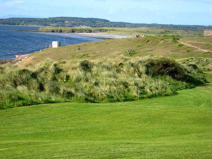
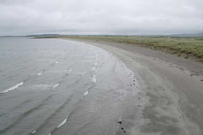
Rosses Point Beach, situated between the Drumcliff Bay Special Protection Area and the Cummeen Strand/Drumcliff Bay Special Area of Conservation, is a sheltered sandy beach, backed by sand dunes. Visitors can enjoy a coastal walk along Rosses Point Penninsula and harbour, which continues along the headland to the beach. Activities such as running, walking, and kite surfing are available on this approximately 1.5km long beach. The bathing area, however, covers only about 300m of the total length.
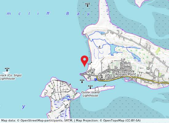
The beach is popular for running, walking and kite surfing. There is car parking adjacent to the beach. Public toilets are also available in the vicinity of the beach. Lifeguard cover is provided during the bathing season. A local bus service operates in the area. There is plenty of holiday accommodation, including guesthouses, hotel, camping and caravanning all in the vicinity of the beach. Rosses point Yacht Club is nearby and they provide sailing courses during the summer off shore. The RNLI also have a base at Rosses Point. There is a nice coastal walk along Rosses Point Penninsula and harbour which continues along the headland to Rosses Point beach. Activities prohibited are those listed in the Beach Bye Laws 2007. These can be viewed on Sligo County Council's Website under Water Safety, www. sligococo. ie. and on the beach notice board. Map 1: Bathing Water Location & Extent
Rosses Point Beach is located approximately 8km north west of Sligo Town at the end of the Rosses Point peninsula. The beach is west facing with Drumcliff Bay to the north and Sligo Bay to the south. The beach area is divided by a small prominentary, creating two beaches known locally as the first (more southerly and much smaller) and second beaches. Rosses Point beach is a fine sandy beach, approximately 1.5km in length, and is backed by sand dunes and a golf course. The bathing area which is patrolled by lifeguards during the bathing season is approximately 300m in length.
: Rosses Point Beach is a sheltered sandy beach, backed by sand dunes.

Weather forecast
Rosses Point Beach on the map
Report water temp:

Photos near Rosses Point Beach

Oliver Dixon
Photo: Oliver Dixon CC BY-SA 2.0
Do you have a nice picture from Rosses Point Beach?
By uploading an image, you certify that you own the image and that it may be displayed on beachguideireland.com

Reviews of Rosses Point Beach

No reviews of Rosses Point Beach yet...
Please help the next visitor by writing a few lines about the beach, are there toilets? Is it shallow? Is there a jetty or maybe a kiosk?
What do you think of the beach?

Beaches close to Rosses Point Beach

Streedagh Beach ⟼ 10.8 km away
Streedagh Beach is a sandy beach that features sand dunes and diverse herbaceous vegetation. Nearby, there is an estuary with sand flats and salt marsh, which supports a variety of plant species. The beach is included in the Streedagh Point Dunes Special Area of Conservation due to its unique tombolo formation, connecting Conor's Island to Streedagh Point, spanning about 2.5 km.
Dunmoran Beach ⟼ 11.1 km away
Dunmoran Beach is a sandy beach with sand dunes as its backdrop. Though not formally designated, a proposed National Heritage Area (pNHA) and a Special Protection Area (SPA) (Ref. SPA 004133) are close by at Aughris. The beach stretches 0.85km, with a designated 400m bathing area.
Mullaghmore Beach ⟼ 18.7 km away
Mullaghmore Beach, situated within the Bunduff Lough and Machair Special Area of Conservation (SAC), is a tranquil, sheltered sandy beach with sand dunes that support diverse plant species. The beach is also home to a range of wildlife, and boasts offshore reefs. In addition, the nearby Mullaghmore Sailing Club offers summer sailing courses. While the bathing area is around 300m long, the beach itself spans over 2km.
Bundoran ⟼ 27.2 km away
Bundoran beach is a sheltered bay with a sandy beach facing Donegal Bay and the Atlantic. The sandbank is large and changes with the tides. It is home to a diverse range of plant and animal species, including rare birds, making it an ideal location for bird watching and ecological activities. Activities include swimming, surfing, football, kite flying, and other land-based activities.
Rossnowlagh ⟼ 35.7 km away
Rossnowlagh is a west-facing sandy beach located in Donegal Bay SPA. Its landscape is defined by the Coolmore cliffs to the South and Inishfad at Durnesh Lake to the North. It offers a diverse range of wildlife, including birds and seals. Visitors can enjoy a variety of activities such as swimming, kayaking, surfing, sailing, diving, and land-based activities. The designated bathing area covers 0.9054km2, with over 2150m of coastline. The water depth slopes gradually, reaching one meter approximately 20m from the water line.
Enniscrone Beach ⟼ 36 km away
Enniscrone Beach is a sandy beach with sand dunes, a caravan park, and a golf course. It is designated as a Special Protection Area (SPA 004036) and Special Area of Conservation (SAC 000458), as part of the Killala Bay/Moy Estuary. There is a shellfish area in Killala Bay, west of Bartra Island. The beach is around 4.5km long, but the patrolled bathing area is approximately 500m. A short coastal walk is available to the north of Enniscrone pier. More information can be found on the NPWS website.
Fintra ⟼ 36.6 km away
Fintra Beach is a picturesque sandy beach located in a small inlet to the West of Killybegs Harbour. The beach features hills and small cliffs to the west and the estuary of the Fintragh River to the East. It is home to varied coastal habitats, including sand dunes, marine water, and low lying grass lands. Vegetated sea cliffs are the dominant feature of the site, with areas of blanket bog and dry heath also present. Visitors can enjoy a range of activities such as swimming, kayaking, boating, diving, and land-based recreational activities. The designated bathing area spans 0.2055km2 and extends approximately 670m along the water. The water depth reaches 1m roughly 20m from the waterline, with a medium gradient off the beach.
Ross Beach, Killala ⟼ 41.3 km away
Ross Strand is a sandy beach on the shore of Killala Bay, encompassing extensive habitats such as mudflats, saltmarshes, and sand dunes that sustain a diverse range of vegetation and wildlife species. It is part of the 004036 Killala Bay/Moy Estuary (SPA) & 000458 Killala Bay/Moy Estuary (SAC). Killala Bay is a Class A and B Shellfish Production Area. Ross Strand affords opportunities for surfing, canoeing, and angling. The bathing area is about 0.30km wide, and the water covers an area of about 0.60km2. The water levels vary between 0.5m and 4.0m depending on the tides.
Murvagh ⟼ 42.1 km away
Murvagh Beach is a shallow, sandy beach surrounded by sand dunes in Donegal Bay, which has a range of intertidal habitats. The beach supports various plant species and is home to diverse wildlife. It has been designated as an SAC, a proposed NHA, and a SPA. Activities at the beach include swimming, kayaking, boating, windsurfing, walking, football, and kite flying. The bathing area covers approximately 2.324km2 and extends along the water for approximately 3770m. The water depth on the shoreline gradually slopes from 0.25 meters to over 0.5 meters.
Beach Guide Ireland Source for water samples and information: the Environmental Protection Agency, users of the site and local municipalities.
Source for weather data: Met Éireann© (CC BY 4.0) Disclaimer: Met Éireann does not accept any liability whatsoever for any error or omission in the data, their availability, or for any loss or damage arising from their use.
Source of satellite-read water temperature: Copernicus Sentinel satellite data from the European Space Agency.