Please help the next visitor by writing a few lines about the beach, are there toilets? Is it shallow? Is there a jetty or maybe a kiosk?
Beaches close to Mullaghmore Beach
Streedagh Beach is a sandy beach that features sand dunes and diverse herbaceous vegetation. Nearby, there is an estuary with sand flats and salt marsh, which supports a variety of plant species. The beach is included in the Streedagh Point Dunes Special Area of Conservation due to its unique tombolo formation, connecting Conor's Island to Streedagh Point, spanning about 2.5 km.
Bundoran beach is a sheltered bay with a sandy beach facing Donegal Bay and the Atlantic. The sandbank is large and changes with the tides. It is home to a diverse range of plant and animal species, including rare birds, making it an ideal location for bird watching and ecological activities. Activities include swimming, surfing, football, kite flying, and other land-based activities.
Rossnowlagh is a west-facing sandy beach located in Donegal Bay SPA. Its landscape is defined by the Coolmore cliffs to the South and Inishfad at Durnesh Lake to the North. It offers a diverse range of wildlife, including birds and seals. Visitors can enjoy a variety of activities such as swimming, kayaking, surfing, sailing, diving, and land-based activities. The designated bathing area covers 0.9054km2, with over 2150m of coastline. The water depth slopes gradually, reaching one meter approximately 20m from the water line.
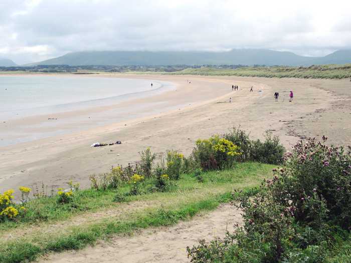
Rosses Point Beach, situated between the Drumcliff Bay Special Protection Area and the Cummeen Strand/Drumcliff Bay Special Area of Conservation, is a sheltered sandy beach, backed by sand dunes. Visitors can enjoy a coastal walk along Rosses Point Penninsula and harbour, which continues along the headland to the beach. Activities such as running, walking, and kite surfing are available on this approximately 1.5km long beach. The bathing area, however, covers only about 300m of the total length.
Fintra Beach is a picturesque sandy beach located in a small inlet to the West of Killybegs Harbour. The beach features hills and small cliffs to the west and the estuary of the Fintragh River to the East. It is home to varied coastal habitats, including sand dunes, marine water, and low lying grass lands. Vegetated sea cliffs are the dominant feature of the site, with areas of blanket bog and dry heath also present. Visitors can enjoy a range of activities such as swimming, kayaking, boating, diving, and land-based recreational activities. The designated bathing area spans 0.2055km2 and extends approximately 670m along the water. The water depth reaches 1m roughly 20m from the waterline, with a medium gradient off the beach.
Murvagh Beach is a shallow, sandy beach surrounded by sand dunes in Donegal Bay, which has a range of intertidal habitats. The beach supports various plant species and is home to diverse wildlife. It has been designated as an SAC, a proposed NHA, and a SPA. Activities at the beach include swimming, kayaking, boating, windsurfing, walking, football, and kite flying. The bathing area covers approximately 2.324km2 and extends along the water for approximately 3770m. The water depth on the shoreline gradually slopes from 0.25 meters to over 0.5 meters.
Dunmoran Beach is a sandy beach with sand dunes as its backdrop. Though not formally designated, a proposed National Heritage Area (pNHA) and a Special Protection Area (SPA) (Ref. SPA 004133) are close by at Aughris. The beach stretches 0.85km, with a designated 400m bathing area.
Naran beach is a sheltered cove beach, located on the Atlantic coast of Ireland, spanning 2km in length. It boasts a vast sandy beach with stunning sand dunes and a diverse range of coastal and terrestrial habitats. This area has been designated a National Heritage Area and a Special Area of Conservation, making it an ideal location for bird watching and ecological activities. Visitors can enjoy various water-based activities like swimming, kayaking, boating, windsurfing, and land-based activities like football, kite flying, and walking. The designated bathing area is approximately 0.9685km2 with a shoreline length of 2120m. The water depth increases from the shoreline within 2 meters to 1 meter and gradually rises to over 2 meters.
Dooey is near Glenties and Dungloe on the west coast of County Donegal. The Atlantic beach is around 3km long and faces west, getting a powerful wash of water from the rough sea. The beach is sheltered to the north by a headland and bounded to the south by the Gweebarra estuary. It is situated in a rural location and backed by a remarkable sand dune system with a defined primary duneridge.
Enniscrone Beach is a sandy beach with sand dunes, a caravan park, and a golf course. It is designated as a Special Protection Area (SPA 004036) and Special Area of Conservation (SAC 000458), as part of the Killala Bay/Moy Estuary. There is a shellfish area in Killala Bay, west of Bartra Island. The beach is around 4.5km long, but the patrolled bathing area is approximately 500m. A short coastal walk is available to the north of Enniscrone pier. More information can be found on the NPWS website.