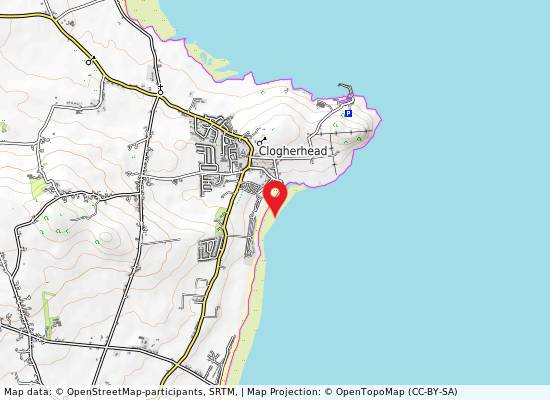
jai
Photo: jai CC BY-SA 2.0

Clogherhead

Rating: 3.0/5 (1 vote)

  • Water temp(satellite):
  • 13.0°C
  • 2024-10-14

Clogherhead is a beach in Louth. During the bathing season, a life guard is on duty. The beach is equipped with toilets and a parking lot. Dogs on lead allowed. Beach wheelchair is available. Beach Wheelchair available from Celtic Canoes Clogherhead contact David Reddy (085) 8758092Public bus
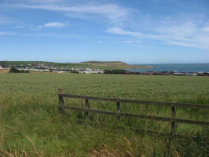
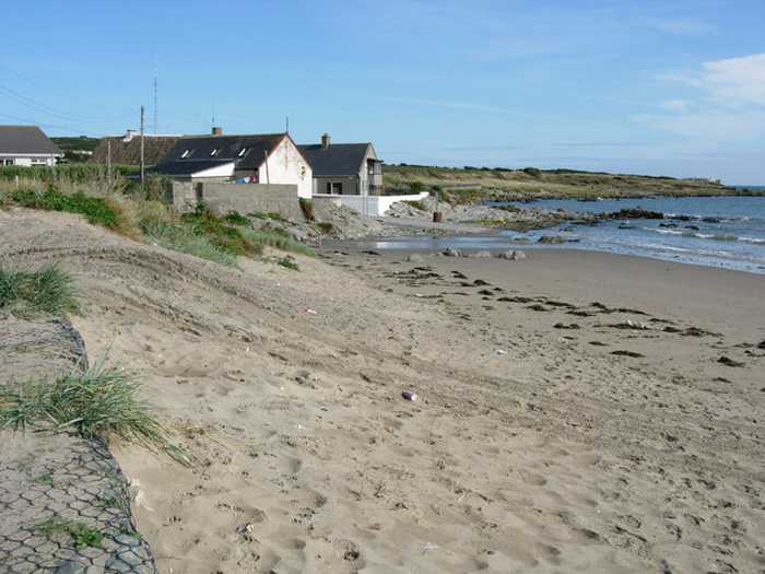
Clogherhead beach is a spacious and gently sloping sandy beach located mainly to the east, with rock and dune formations to the north. Two small rip currents exist at the beach's northern end, while the area features sand dunes and rocks, as well as a variety of marine life, such as crabs, jellyfish, sea beet, and limpets. To preserve the beach, Foreshore Byelaws 2003 prohibit motorized vehicles from entering the area. During peak season, an estimated 200 visitors visits the beach daily, which has a gently sloping bating area spreading over a length of roughly 1430 meters.
The Foreshore Byelaws 2003 are in existence to exclude motorized vehicles from the beach. The average daily visitor numbers to this beach estimated during the bathing season is 200.
The fishing village of Clogherhead is located on the east coast of Ireland in the County of Louth, approximately 70km north of Dublin. The headland affords uninterrupted views of the Cooley and Mourne Mountains 30km to the north and to Lambay Island 35km to the south. The village is in close proximity to the historic town of Drogheda. The village developed around the fishing industry with the waters of Clogherhead reputed as being the best fishing waters in the country. The harbour, known as Port Oriel was built in 1885. It was extensively enlarged and re-opened in 2007.
Clogherhead beach is a large open sandy beach that is gently sloping. The beach is facing mainly to the east. It is bordered to the north by a small headland and the designated bathing area extends for approximately 1430 meters to the south. The beach is bordered by a carpark and caravan park to the rear. There is an area of dunes that extends from beyond the carpark along the rear of the beach. There is an area of rocks to the north (outside the designated bathing area that are partially submerged at high tide. There are two small rip currents at the north end of the beach. The bathing area is approximately 1430m in length.

Weather forecast
Clogherhead on the map
Report water temp:

Photos near Clogherhead

Kieran Campbell
Photo: Kieran Campbell CC BY-SA 2.0
Do you have a nice picture from Clogherhead?
By uploading an image, you certify that you own the image and that it may be displayed on beachguideireland.com

Reviews of Clogherhead

No reviews of Clogherhead yet...
Please help the next visitor by writing a few lines about the beach, are there toilets? Is it shallow? Is there a jetty or maybe a kiosk?
What do you think of the beach?

Beaches close to Clogherhead

Seapoint ⟼ 3.3 km away
Seapoint Beach is a spacious expanse of sand and shingle, with its bathing water situated adjacent to sand dunes. Its designated 1270m long bathing area is separated by the Termonfeckin River. Additionally, to the south, there are some small rocky sections and sand bars.
Port, Lurganboy ⟼ 4.8 km away
The beach is predominantly composed of sand, with a minor section of rocky formations that are interspersed with sand dunes. These dunes, in turn, provide a thriving habitat for a diversity of plant species, contributing to the ecological value of the area. Additionally, a range of fauna, such as crabs and seaweed, are present on the site. It is important to note that the contiguous conservation-designated zones in close proximity to the beach are Clogherhead SAC and Dunany Point NHA. The beach spans a length of approximately 2300 meters, and the area designated for swimming gradually descends into the ocean.
Mornington ⟼ 7.4 km away
Mornington beach is a beautiful sandy beach bordered by sand dunes, situated between the Boyne estuary and Bettystown. To preserve the dunes' conservation value, boardwalks are available for beach access. These dunes are a part of the Boyne Coast and Estuary Special Area of Conservation (SAC site code 001957), with the Boyne estuary designated as a Special Protected Area (SPA site code 004080).
Laytown/Bettystown ⟼ 9.4 km away
Laytown/Bettystown is a stunning beach with fine sand and sand dunes that is home to a links golf course. The area to the north is a Special Area of Conservation (SAC site code 001957), known as the Boyne Coast and Estuary, while the south is a designated Special Protected Area (SPA site code 004158), specifically the River Nanny Estuary and Shore. Visitors can partake in a variety of beach activities, including sandsculpting and kitesurfing, and Laytown/Bettystown has also hosted the National Sand Sculpting and Sandcastle Competition. An annual event, the Laytown Strand Race, takes place on the beach, which has a bathing area approximately 1.5 km long and 0.6 km2 in size.
Balbriggan, Front Strand Beach ⟼ 19.5 km away
Balbriggan Front Beach is a compact sandy beach that is adjacent to a functioning harbor.
Shelling Hill/Templetown ⟼ 22.4 km away
Templetown Beach is a spacious, south-facing beach, comprised of sand and shingle. The bathing water is situated in close proximity to the sandy dunes which house a range of plant species and wildlife, including limpets and crabs. The designated bathing area spans 0.2Km whilst the beach extends in both directions beyond the designated area. The beach gradually slopes into the sea.
Skerries, South Beach ⟼ 24.2 km away
Skerries South Beach is a lengthy sandy shore that gradually slopes towards the sea. The beach's northern edge is demarcated by the Red Island headland rocks.
Loughshinny Beach ⟼ 28.4 km away
Loughshinny Beach is a small, sheltered sandy cove that gently slopes down. It is located in close proximity to Loughshinny harbour, which is a bustling fishing hub situated to the east of the beach.
Rush North Beach ⟼ 30.5 km away
Rush North Beach is a sandy beach with a large dune area at the back, gently sloping and bordered by Rush Harbour on the South and a rocky headland on the North.
Rush, South Beach ⟼ 31.4 km away
South Beach Rush is a sandy beach with a sloping landscape and a large sandy dune area in the rear. The beach is partially sheltered by a rocky headland to the North.
Beach Guide Ireland Source for water samples and information: the Environmental Protection Agency, users of the site and local municipalities.
Source for weather data: Met Éireann© (CC BY 4.0) Disclaimer: Met Éireann does not accept any liability whatsoever for any error or omission in the data, their availability, or for any loss or damage arising from their use.
Source of satellite-read water temperature: Copernicus Sentinel satellite data from the European Space Agency.