Joseph Mischyshyn
Photo: Joseph Mischyshyn CC BY-SA 2.0

Portarthur, Derrybeg

Rating: 0.0/5 (0 votes)

  • Water temp(satellite):
  • 12.9°C
  • 2024-10-14

Portarthur, Derrybeg is a beach in Donegal. Parking close to the beach. Dogs must be kept on a leash at all times. Improved accessibility for people with disabilities.
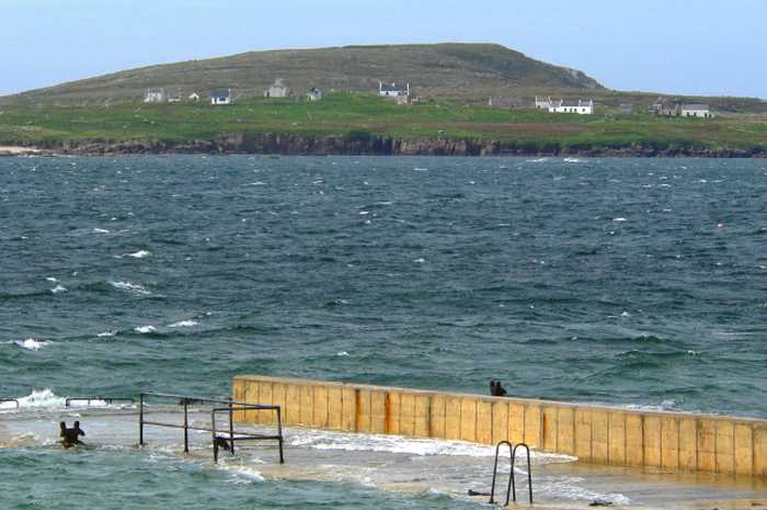
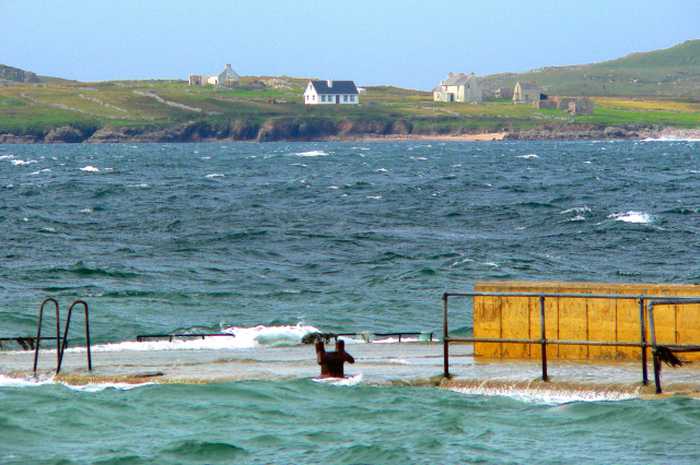
Portarthur Beach is a north-facing sandy beach, bounded by a rocky outcrop east of Inishmeane Island and a small estuary to the south. The area features fixed dunes that support a variety of plant life, including some rare species. Birdwatchers can enjoy observing a diverse range of birds. Visitors can engage in several water and beach activities, such as swimming, kayaking, boating, and jet skiing, with a designated bathing area covering approximately 0.225km2 of the beach. The beach has a deep gradient, with the water depth reaching 1m just 10m from the water line and continuing at a steep slope. The beach is located in a Gaeltacht area with numerous islands off the coast.
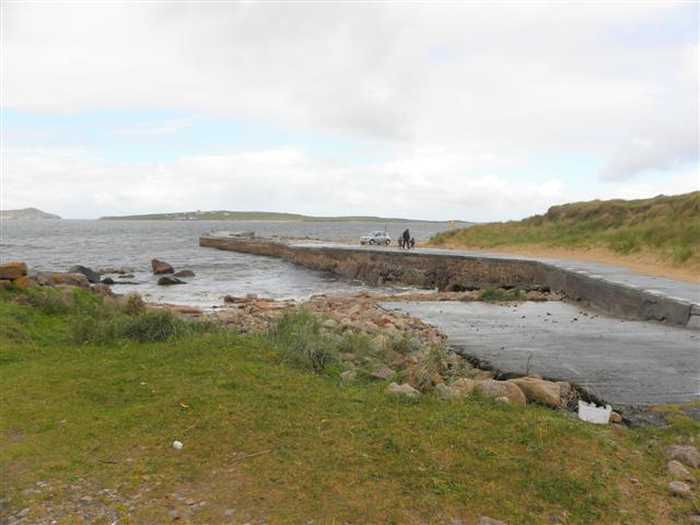
Facilities: Limited parking is available at the pier, for all other facilities Derrybeg and Bunbeg (5km & 6km) have shops, pubs, hotels, toilets, banks, restaurants, etc. Other facilities are also present at Carrickfinn Blue Flag Beach (beside Donegal Airport, 16km drive) such as a larger car park, toilets (seasonal), information boards, though Carrickfinn Beach operates a system of Pack It In, Pack It Out (PIIPIO) which does not provide refuse or recycling facilitiesrecycling facilities can be found at Molloy’s Supermarket in Derrybeg. Visitor Numbers: Visitor numbers to the beach vary throughout the season. The maximum number of visitors to the beach during a high season day has been estimated at approximately 300 people with a large proportion if users using the beach for walking and other for boating activities. Throughout the season approximately 5,000 people have been estimated to visit the beach. Visitor numbers are representative of the visitors observed by the water quality samplers and from local information. Activities: Activities at Port Arthur beach include swimming, kayaking, boating, sailing, power boating, jet skiing, diving and other land based activities on the beach. The area is prominent locally for walkers.
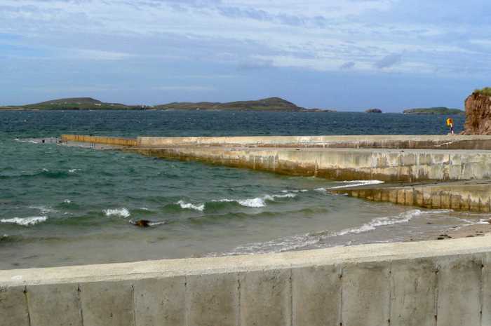
Portarthur Beach is located to the West of Gweedore, approximately 7km South of Bloody Foreland, on the West coast of County Donegal. The beach is situated in a rural area and not directly beside any towns or villageswith the nearest villages being Derrybeg (5km) or Bunbeg (6km). It is located in the Northwestern Atlantic Seaboard Coastal waterbody (NW_100_0000) within the North Western River Basin District. The designated bathing area is approx. 0.225km2 and the extent along the water is approximately is 1070m
: Portarthur beach consists of a long sandy beachconfined by a rocky outcrop east of Inishmeane Island to the North and a small estuary to the south. The beach faces west onto the Atlantic Ocean and get a relatively strong wash of water onto the beach but is protected to an extent by the network of small islands in the area.

Weather forecast
Portarthur, Derrybeg on the map
Report water temp:

Photos near Portarthur, Derrybeg

Joseph Mischyshyn
Photo: Joseph Mischyshyn CC BY-SA 2.0
Joseph Mischyshyn
Photo: Joseph Mischyshyn CC BY-SA 2.0
Kenneth  Allen 
Photo: Kenneth Allen  CC BY-SA 2.0
Do you have a nice picture from Portarthur, Derrybeg?
By uploading an image, you certify that you own the image and that it may be displayed on beachguideireland.com

Reviews of Portarthur, Derrybeg

No reviews of Portarthur, Derrybeg yet...
Please help the next visitor by writing a few lines about the beach, are there toilets? Is it shallow? Is there a jetty or maybe a kiosk?
What do you think of the beach?

Beaches close to Portarthur, Derrybeg

Carrickfinn ⟼ 6.7 km away
Carrickfinn is a spacious beach with a strong dune system situated in Gweedore Bay, a Natural Heritage Area hosting diverse coastal habitats and plant and animal life. It is affected by tidal changes during the day.
Magheraroarty ⟼ 10.4 km away
Magheraroarty is a rural area situated on the North Coast of Donegal, around 9 km away from Falcarragh town. The beach in Magheraroarty is a long sandy one, located on a strip of land with the Atlantic Ocean and Ballyness Bay on either side and Inishbofin island to the North. As it is west facing, the beach receives a strong wash of water from the rough sea, and the coastline is lined with shifting dunes, vegetated by Marram Grass. Additionally, the fixed dunes in the Magheraroarty dune ecosystem contain humid dune slacks.
Drumnatinny ⟼ 16 km away
Drumnatinny beach is a north-facing sandy stretch, with Ballyness Bay to the West and Crockagarran and headlands to the East. The dunes here have several plant species and the beach has a variety of bird and animal life. Low tides expose expansive mud and sand flats in Ballyness Bay. Popular activities include swimming, kayaking, surfing, and power boating. The beach has a designated bathing area of approximately 1.317km2, sloping evenly to a depth of 1m about 10m from the water line.
Killahoey ⟼ 24.9 km away
Killahoey beach is a diverse coastal site comprising of sandy beaches, mud flats, sand flats, dunes and a brackish lake. It is a proposed NHA and part of a SAC, supporting various wildlife species. The bathing area is around 0.6707km2 and 1570m in length. Water depth gradually increases from 2 meters off-shore to greater than 2 meters with the shoreline slope. Activities include swimming, kayaking, boating, windsurfing, football, horse riding, kite flying, etc.
Dooey ⟼ 25.6 km away
Dooey is near Glenties and Dungloe on the west coast of County Donegal. The Atlantic beach is around 3km long and faces west, getting a powerful wash of water from the rough sea. The beach is sheltered to the north by a headland and bounded to the south by the Gweebarra estuary. It is situated in a rural location and backed by a remarkable sand dune system with a defined primary duneridge.
Portnablagh ⟼ 26.2 km away
Portnablagh beach is a small sandy beach in Ireland, confined by Portnablagh pier and a headland. It supports wildlife including birds and shellfish, making it a part of a Special Protection Area under the E.U. Birds Directive. Due to rare species, it holds special conservation interest. The beach offers various activities like swimming, kayaking, boating, windsurfing, sailing, surfing, power boating, jet skiing, diving and land-based activities. It is located beside a small working pier and slipway, however, the water off the beach gets deep quickly, with depth reaching 1m around 10m from the water line, and continuing further out in a deep slope.
Marble Hill ⟼ 27.7 km away
Marble Hill beach has a sandy coastline with two rock formations towards the east, visible during certain tidal phases. Its sand dunes support an array of plant species and the beach is home to various wildlife, making it a significant part of the Sheephaven SAC. Aside from land-based activities like football and kite flying, water activities such as swimming, kayaking, boating and windsurfing can be enjoyed in its designated 0.4415km2 bathing area. The water depth increases gradually from 2 meters off the shore to greater than 2 meters along the sloping shoreline.
Naran ⟼ 30.1 km away
Naran beach is a sheltered cove beach, located on the Atlantic coast of Ireland, spanning 2km in length. It boasts a vast sandy beach with stunning sand dunes and a diverse range of coastal and terrestrial habitats. This area has been designated a National Heritage Area and a Special Area of Conservation, making it an ideal location for bird watching and ecological activities. Visitors can enjoy various water-based activities like swimming, kayaking, boating, windsurfing, and land-based activities like football, kite flying, and walking. The designated bathing area is approximately 0.9685km2 with a shoreline length of 2120m. The water depth increases from the shoreline within 2 meters to 1 meter and gradually rises to over 2 meters.
Downings ⟼ 31.7 km away
Downings beach is a sandy beach located in Sheephaven Bay, bounded by Downings pier to the west and Maslack headland to the south. At low tide, a sea cave in the Maslack headland is exposed. The surrounding Peninsula boasts diverse coastal habitats, including high rock cliffs, offshore islands, sand dunes, salt marshes, a large intertidal bay, and rocky shingle and sandy beaches, which support various wildlife and vegetation. The beach offers a range of activities such as swimming, kayaking, windsurfing, sailing, surfing, power boating, jet skiing (outside the designated area), diving, and other land-based activities. The designated bathing area covers an area of approximately 0.273km2, with a water line of approximately 687m. The beach slopes very gently, with the water depth reaching 1m about 50m away from the water line.
Ballyhiernan, Fanad ⟼ 42.2 km away
Ballyhiernan beach is a beautiful sandy beach located in the north with stunning sand dunes. The beach boasts three bays - Carrickachurdin Bay, Kinlackagh Bay and Trabane Bay. It's a haven for wildlife lovers as the beach is home to a diverse range of birds, and even features two notable species - the Common Frog and Irish Hare. Furthermore, the beach is perfect for adventure enthusiasts as it offers a wide range of activities, both water, and land-based such as kayaking, surfing, power boating, and more.
Beach Guide Ireland Source for water samples and information: the Environmental Protection Agency, users of the site and local municipalities.
Source for weather data: Met Éireann© (CC BY 4.0) Disclaimer: Met Éireann does not accept any liability whatsoever for any error or omission in the data, their availability, or for any loss or damage arising from their use.
Source of satellite-read water temperature: Copernicus Sentinel satellite data from the European Space Agency.