Joseph Mischyshyn
Photo: Joseph Mischyshyn CC BY-SA 2.0

Naran

Rating: 5.0/5 (1 vote)

  • Water temp(satellite):
  • 13.0°C
  • 2024-10-14

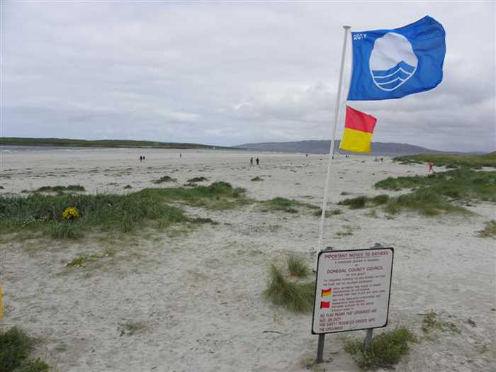
Naran is located in the county of Donegal. During bathing season, a lifeguard is on duty. Toilets and parking lot near the beach. Dogs must be kept on a leash at all times. The beach is accessible to guests with disabilities. Beach wheelchair is available. Prior to visit please contact, Mary Nicholson at 074 9545216.
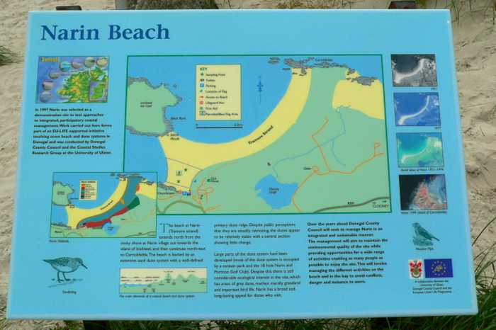
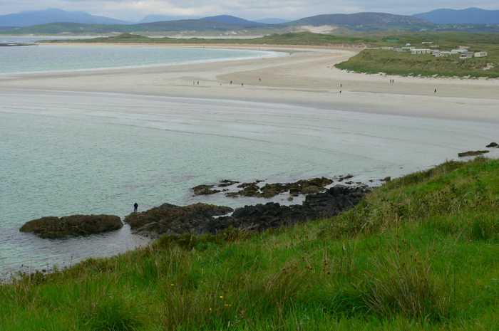
Naran beach is a sheltered cove beach, located on the Atlantic coast of Ireland, spanning 2km in length. It boasts a vast sandy beach with stunning sand dunes and a diverse range of coastal and terrestrial habitats. This area has been designated a National Heritage Area and a Special Area of Conservation, making it an ideal location for bird watching and ecological activities. Visitors can enjoy various water-based activities like swimming, kayaking, boating, windsurfing, and land-based activities like football, kite flying, and walking. The designated bathing area is approximately 0.9685km2 with a shoreline length of 2120m. The water depth increases from the shoreline within 2 meters to 1 meter and gradually rises to over 2 meters.
Facilities: Facilities available at the beach include car parking, toilets (seasonal), information boards, recycling facilities, refuse bins and lifeguards (seasonal). During the lifeguarded periods, extra facilities provided by the lifeguards include: emergency information, telephone access, first aid equipment and rescue equipment. There are shops, restaurants etc available town of Glenties approximately 10km from the beach. Local shops, bars and restaurants (seasonal opening) are within walking distance and there are three caravan sites close to the strand area. Visitor Numbers: Visitor numbers to the beach vary throughout the season. The maximum number of visitors to the beach during a high season day has been estimated at approximately 1,500 people with approximately half of this number swimming. Throughout the season approximately 20,000 people have been estimated to visit the beach. Visitor numbers are representative of the visitors recorded by the lifeguards that are on duty during the bathing season. Activities: Activities at Naran Beach include swimming, kayaking, boating, windsurfing and other land-based activities such as football, kite flying and walking.
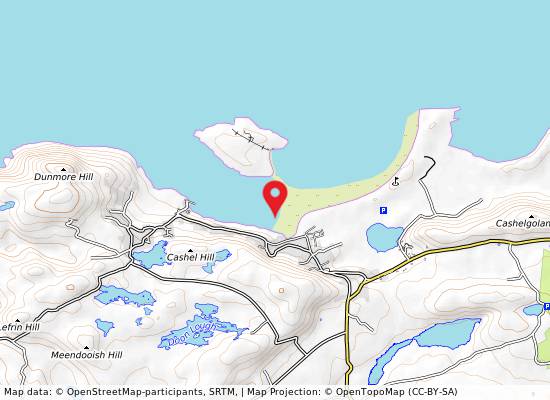
Naran (Phort Nua) Blue Flag Beach is located close to the town of Glenties which is located on the western coast of County Donegal. It is located in the Gweebarra Bay Coastal waterbody (NW_120_0000) within the North Western River Basin District. The bathing area is designated and is approx. 0.9685km2 and the extent along the water is approximately is 2120m.
: Naran beach is a sheltered cove beach approximately 2km long on the Atlantic coast of Ireland. The beach is contained to the west by low lying land and sheltered to the north-west by the estuary and land opposite. Access to an island can be gained at low tide as a sand spit dries out.

Weather forecast
Naran on the map
Report water temp:

Photos near Naran

Joseph Mischyshyn
Photo: Joseph Mischyshyn CC BY-SA 2.0
Kenneth  Allen 
Photo: Kenneth Allen  CC BY-SA 2.0
Do you have a nice picture from Naran?
By uploading an image, you certify that you own the image and that it may be displayed on beachguideireland.com

Reviews of Naran

No reviews of Naran yet...
Please help the next visitor by writing a few lines about the beach, are there toilets? Is it shallow? Is there a jetty or maybe a kiosk?
What do you think of the beach?

Beaches close to Naran

Dooey ⟼ 5.3 km away
Dooey is near Glenties and Dungloe on the west coast of County Donegal. The Atlantic beach is around 3km long and faces west, getting a powerful wash of water from the rough sea. The beach is sheltered to the north by a headland and bounded to the south by the Gweebarra estuary. It is situated in a rural location and backed by a remarkable sand dune system with a defined primary duneridge.
Fintra ⟼ 22.9 km away
Fintra Beach is a picturesque sandy beach located in a small inlet to the West of Killybegs Harbour. The beach features hills and small cliffs to the west and the estuary of the Fintragh River to the East. It is home to varied coastal habitats, including sand dunes, marine water, and low lying grass lands. Vegetated sea cliffs are the dominant feature of the site, with areas of blanket bog and dry heath also present. Visitors can enjoy a range of activities such as swimming, kayaking, boating, diving, and land-based recreational activities. The designated bathing area spans 0.2055km2 and extends approximately 670m along the water. The water depth reaches 1m roughly 20m from the waterline, with a medium gradient off the beach.
Carrickfinn ⟼ 23.3 km away
Carrickfinn is a spacious beach with a strong dune system situated in Gweedore Bay, a Natural Heritage Area hosting diverse coastal habitats and plant and animal life. It is affected by tidal changes during the day.
Portarthur, Derrybeg ⟼ 30.1 km away
Portarthur Beach is a north-facing sandy beach, bounded by a rocky outcrop east of Inishmeane Island and a small estuary to the south. The area features fixed dunes that support a variety of plant life, including some rare species. Birdwatchers can enjoy observing a diverse range of birds. Visitors can engage in several water and beach activities, such as swimming, kayaking, boating, and jet skiing, with a designated bathing area covering approximately 0.225km2 of the beach. The beach has a deep gradient, with the water depth reaching 1m just 10m from the water line and continuing at a steep slope. The beach is located in a Gaeltacht area with numerous islands off the coast.
Murvagh ⟼ 31.9 km away
Murvagh Beach is a shallow, sandy beach surrounded by sand dunes in Donegal Bay, which has a range of intertidal habitats. The beach supports various plant species and is home to diverse wildlife. It has been designated as an SAC, a proposed NHA, and a SPA. Activities at the beach include swimming, kayaking, boating, windsurfing, walking, football, and kite flying. The bathing area covers approximately 2.324km2 and extends along the water for approximately 3770m. The water depth on the shoreline gradually slopes from 0.25 meters to over 0.5 meters.
Rossnowlagh ⟼ 35.3 km away
Rossnowlagh is a west-facing sandy beach located in Donegal Bay SPA. Its landscape is defined by the Coolmore cliffs to the South and Inishfad at Durnesh Lake to the North. It offers a diverse range of wildlife, including birds and seals. Visitors can enjoy a variety of activities such as swimming, kayaking, surfing, sailing, diving, and land-based activities. The designated bathing area covers 0.9054km2, with over 2150m of coastline. The water depth slopes gradually, reaching one meter approximately 20m from the water line.
Magheraroarty ⟼ 38.3 km away
Magheraroarty is a rural area situated on the North Coast of Donegal, around 9 km away from Falcarragh town. The beach in Magheraroarty is a long sandy one, located on a strip of land with the Atlantic Ocean and Ballyness Bay on either side and Inishbofin island to the North. As it is west facing, the beach receives a strong wash of water from the rough sea, and the coastline is lined with shifting dunes, vegetated by Marram Grass. Additionally, the fixed dunes in the Magheraroarty dune ecosystem contain humid dune slacks.
Bundoran ⟼ 41.3 km away
Bundoran beach is a sheltered bay with a sandy beach facing Donegal Bay and the Atlantic. The sandbank is large and changes with the tides. It is home to a diverse range of plant and animal species, including rare birds, making it an ideal location for bird watching and ecological activities. Activities include swimming, surfing, football, kite flying, and other land-based activities.
Mullaghmore Beach ⟼ 42.2 km away
Mullaghmore Beach, situated within the Bunduff Lough and Machair Special Area of Conservation (SAC), is a tranquil, sheltered sandy beach with sand dunes that support diverse plant species. The beach is also home to a range of wildlife, and boasts offshore reefs. In addition, the nearby Mullaghmore Sailing Club offers summer sailing courses. While the bathing area is around 300m long, the beach itself spans over 2km.
Drumnatinny ⟼ 42.6 km away
Drumnatinny beach is a north-facing sandy stretch, with Ballyness Bay to the West and Crockagarran and headlands to the East. The dunes here have several plant species and the beach has a variety of bird and animal life. Low tides expose expansive mud and sand flats in Ballyness Bay. Popular activities include swimming, kayaking, surfing, and power boating. The beach has a designated bathing area of approximately 1.317km2, sloping evenly to a depth of 1m about 10m from the water line.
Beach Guide Ireland Source for water samples and information: the Environmental Protection Agency, users of the site and local municipalities.
Source for weather data: Met Éireann© (CC BY 4.0) Disclaimer: Met Éireann does not accept any liability whatsoever for any error or omission in the data, their availability, or for any loss or damage arising from their use.
Source of satellite-read water temperature: Copernicus Sentinel satellite data from the European Space Agency.