louise price
Photo: louise price CC BY-SA 2.0

Murvagh

Rating: 0.0/5 (0 votes)

  • Water temp(satellite):
  • 13.4°C
  • 2024-10-14

Murvagh is a beach in Donegal. During the bathing season, a lifeguard is on duty. Near the beach, there are toilets and a parking area. Dogs must be kept on a leash. Guests with disabilities can access the beach.
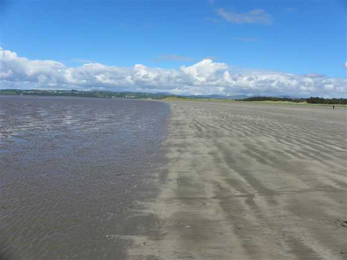
Murvagh Beach is a shallow, sandy beach surrounded by sand dunes in Donegal Bay, which has a range of intertidal habitats. The beach supports various plant species and is home to diverse wildlife. It has been designated as an SAC, a proposed NHA, and a SPA. Activities at the beach include swimming, kayaking, boating, windsurfing, walking, football, and kite flying. The bathing area covers approximately 2.324km2 and extends along the water for approximately 3770m. The water depth on the shoreline gradually slopes from 0.25 meters to over 0.5 meters.
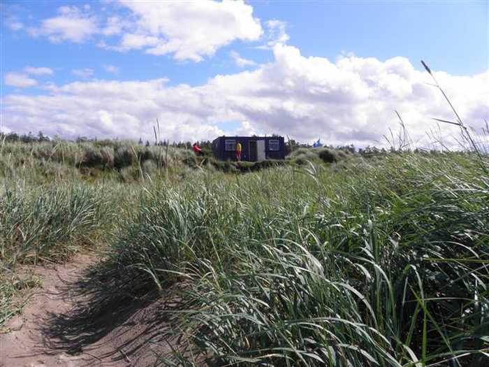
Facilities: Facilities available at the beach include car parking, toilets (seasonal), information boards, refuse bins and lifeguards (seasonal). During the lifeguarded periods, extra facilities provided by the lifeguards include: emergency information, telephone access, first aid equipment and rescue equipment. There are shops, restaurants etc available town of Laghey approximately 5km from the beach. Visitor Numbers: Visitor numbers to the beach vary throughout the season. The maximum number of visitors to the beach during a high season day has been estimated at approximately 300 people with approximately half of this number swimming. Throughout the season approximately 4,500 people have been estimated to visit the beach. Visitor numbers are representative of the visitors recorded by the lifeguards that are on duty during the bathing season. Activities: Activities at Murvagh Beach include swimming, kayaking, boating, windsurfing and other land-based activities such as walking, football, kite flying etc. It is an extremely popular beach for walking. Activities also include boating and fishing in the bay, with a little shellfish aquaculture.
Murvagh (Murbhach) Blue Flag Beach is located close to the village of Laghey which is located on the south western coast of County Donegal. It is located in the Donegal Bay (Erne) Coastal waterbody (NW_010_0000) within the North Western River Basin District. The bathing area is designated and is approx. 2.324km2 and the extent along the water is approximately is 3770m.
: Murvagh beach consists of a sandy beach. These are exposed at times during the tidal phase during the day. The beach is contained to the west by low lying land and sheltered to the north-west by the estuary and land opposite. Murvagh Beach is a long shallow beach. A kilometre of sand banks slows the incoming tide so that the water is barely waist deep for much of the day. Behind the beach are sand dunes, designated as a Special Area of Conservation, and beyond them lies the lovely Murvagh Forest, which has trails and picnic tables.

Weather forecast
Murvagh on the map
Report water temp:

Photos near Murvagh

Kenneth  Allen 
Photo: Kenneth Allen  CC BY-SA 2.0
Kenneth  Allen 
Photo: Kenneth Allen  CC BY-SA 2.0
Do you have a nice picture from Murvagh?
By uploading an image, you certify that you own the image and that it may be displayed on beachguideireland.com

Reviews of Murvagh

No reviews of Murvagh yet...
Please help the next visitor by writing a few lines about the beach, are there toilets? Is it shallow? Is there a jetty or maybe a kiosk?
What do you think of the beach?

Beaches close to Murvagh

Rossnowlagh ⟼ 6.5 km away
Rossnowlagh is a west-facing sandy beach located in Donegal Bay SPA. Its landscape is defined by the Coolmore cliffs to the South and Inishfad at Durnesh Lake to the North. It offers a diverse range of wildlife, including birds and seals. Visitors can enjoy a variety of activities such as swimming, kayaking, surfing, sailing, diving, and land-based activities. The designated bathing area covers 0.9054km2, with over 2150m of coastline. The water depth slopes gradually, reaching one meter approximately 20m from the water line.
Bundoran ⟼ 15.4 km away
Bundoran beach is a sheltered bay with a sandy beach facing Donegal Bay and the Atlantic. The sandbank is large and changes with the tides. It is home to a diverse range of plant and animal species, including rare birds, making it an ideal location for bird watching and ecological activities. Activities include swimming, surfing, football, kite flying, and other land-based activities.
Fintra ⟼ 21 km away
Fintra Beach is a picturesque sandy beach located in a small inlet to the West of Killybegs Harbour. The beach features hills and small cliffs to the west and the estuary of the Fintragh River to the East. It is home to varied coastal habitats, including sand dunes, marine water, and low lying grass lands. Vegetated sea cliffs are the dominant feature of the site, with areas of blanket bog and dry heath also present. Visitors can enjoy a range of activities such as swimming, kayaking, boating, diving, and land-based recreational activities. The designated bathing area spans 0.2055km2 and extends approximately 670m along the water. The water depth reaches 1m roughly 20m from the waterline, with a medium gradient off the beach.
Mullaghmore Beach ⟼ 24.3 km away
Mullaghmore Beach, situated within the Bunduff Lough and Machair Special Area of Conservation (SAC), is a tranquil, sheltered sandy beach with sand dunes that support diverse plant species. The beach is also home to a range of wildlife, and boasts offshore reefs. In addition, the nearby Mullaghmore Sailing Club offers summer sailing courses. While the bathing area is around 300m long, the beach itself spans over 2km.
Naran ⟼ 31.9 km away
Naran beach is a sheltered cove beach, located on the Atlantic coast of Ireland, spanning 2km in length. It boasts a vast sandy beach with stunning sand dunes and a diverse range of coastal and terrestrial habitats. This area has been designated a National Heritage Area and a Special Area of Conservation, making it an ideal location for bird watching and ecological activities. Visitors can enjoy various water-based activities like swimming, kayaking, boating, windsurfing, and land-based activities like football, kite flying, and walking. The designated bathing area is approximately 0.9685km2 with a shoreline length of 2120m. The water depth increases from the shoreline within 2 meters to 1 meter and gradually rises to over 2 meters.
Dooey ⟼ 33.1 km away
Dooey is near Glenties and Dungloe on the west coast of County Donegal. The Atlantic beach is around 3km long and faces west, getting a powerful wash of water from the rough sea. The beach is sheltered to the north by a headland and bounded to the south by the Gweebarra estuary. It is situated in a rural location and backed by a remarkable sand dune system with a defined primary duneridge.
Streedagh Beach ⟼ 33.6 km away
Streedagh Beach is a sandy beach that features sand dunes and diverse herbaceous vegetation. Nearby, there is an estuary with sand flats and salt marsh, which supports a variety of plant species. The beach is included in the Streedagh Point Dunes Special Area of Conservation due to its unique tombolo formation, connecting Conor's Island to Streedagh Point, spanning about 2.5 km.
Rosses Point Beach ⟼ 42.1 km away
Rosses Point Beach, situated between the Drumcliff Bay Special Protection Area and the Cummeen Strand/Drumcliff Bay Special Area of Conservation, is a sheltered sandy beach, backed by sand dunes. Visitors can enjoy a coastal walk along Rosses Point Penninsula and harbour, which continues along the headland to the beach. Activities such as running, walking, and kite surfing are available on this approximately 1.5km long beach. The bathing area, however, covers only about 300m of the total length.
Carrickfinn ⟼ 50 km away
Carrickfinn is a spacious beach with a strong dune system situated in Gweedore Bay, a Natural Heritage Area hosting diverse coastal habitats and plant and animal life. It is affected by tidal changes during the day.
Dunmoran Beach ⟼ 52.4 km away
Dunmoran Beach is a sandy beach with sand dunes as its backdrop. Though not formally designated, a proposed National Heritage Area (pNHA) and a Special Protection Area (SPA) (Ref. SPA 004133) are close by at Aughris. The beach stretches 0.85km, with a designated 400m bathing area.
Beach Guide Ireland Source for water samples and information: the Environmental Protection Agency, users of the site and local municipalities.
Source for weather data: Met Éireann© (CC BY 4.0) Disclaimer: Met Éireann does not accept any liability whatsoever for any error or omission in the data, their availability, or for any loss or damage arising from their use.
Source of satellite-read water temperature: Copernicus Sentinel satellite data from the European Space Agency.