Kieran Evans
Photo: Kieran Evans CC BY-SA 2.0

Downings

Rating: 0.0/5 (0 votes)

  • Water temp(satellite):
  • 12.8°C
  • 2024-10-14

Downings is located in the county of Donegal. During the bathing season, a life guard is on duty. There are toilets and a parking lot near the beach. Dogs must be on a leash at all times. People with disabilities can access the beach. Beach wheelchair is available. Beach Wheelchair is available via the Downings Tidy Towns by arrangement (087 6152351)
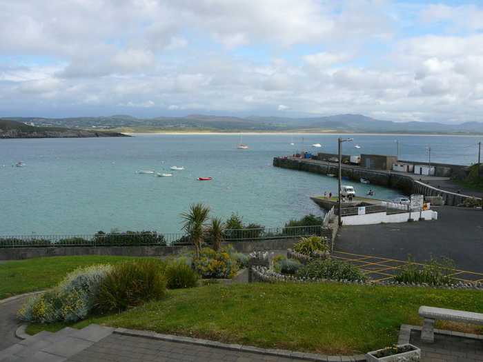
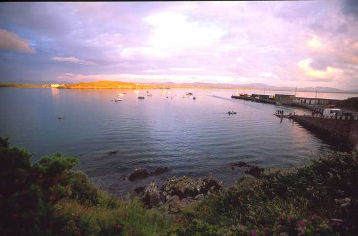
Downings beach is a sandy beach located in Sheephaven Bay, bounded by Downings pier to the west and Maslack headland to the south. At low tide, a sea cave in the Maslack headland is exposed. The surrounding Peninsula boasts diverse coastal habitats, including high rock cliffs, offshore islands, sand dunes, salt marshes, a large intertidal bay, and rocky shingle and sandy beaches, which support various wildlife and vegetation. The beach offers a range of activities such as swimming, kayaking, windsurfing, sailing, surfing, power boating, jet skiing (outside the designated area), diving, and other land-based activities. The designated bathing area covers an area of approximately 0.273km2, with a water line of approximately 687m. The beach slopes very gently, with the water depth reaching 1m about 50m away from the water line.
Facilities: Facilities available at the beach include car parking, toilets (seasonal), information boards, recycling, refuse bins and lifeguards (seasonal). During the lifeguarded periods, extra facilities provided by the lifeguards include: emergency information, telephone access, first aid equipment and rescue equipment. There are shops, restaurants, cafes etc available in Downings village approximately 300m from the beach. Cars are permitted to drive on the Eastern side of Downings Beach with the car free zone delineated with yellow markers to the West which is also the zone patrolled by the Lifeguards. Visitor Numbers: Visitor numbers to the beach vary throughout the season. The maximum number of visitors to the beach during a high season day has been estimated at approximately 1,200 people with a large proportion if users using the water for swimming and a variety of recreational water sports. Throughout the season approximately 35,000 people have been estimated to visit the beach. Visitor numbers are representative of the visitors recorded by the lifeguards that are on duty during the bathing season. Activities: Activities at Downings beach include swimming, kayaking, boating, windsurfing, sailing, surfing, power boating, jet skiing (outside the designated area which is defined in Schedule C of the Maritime Craft Bye Laws), diving and other land based activities on the beach. Gartan Outdoor Education Centre run a training school and provide rentals during the summer period for sailing, windsurfing and canoeing. Jaws Watersports at the main entrance to the beach, also does rentals of stand up paddle boards, surf boards and kayaks. The United Beach Missions run activities on the beach for a week during the summer.
Downings Beach is located close to the village of Downings (Na Dúnaibh), which is located in a Gaeltacht area on the Rosguill Peninsula in County Donegal. It is located in the Sheephaven Coastal waterbody (NW_190_0000) running into the Northwestern Atlantic Seaboard Coastal waterbody (NW_100_0000) within the North Western River Basin District. The designated bathing area is approx. 0.273km2 and the extent along the water is approximately is 687m. There are 3 main entrances onto the beachfrom the middle of the village, there is the access route for vehicles and a large car parkthere are two sets of steps to the west of the entrance, one beside the lifeguard hut and the other from the pier.
: Downings beach consists of a sandy beach in Sheephaven Bay that is confined by Downings pier to the west and a small headland called Maslack to the South. There is a sea cave in the Maslack headland that is exposed at low tide. There is a small stream that comes onto the beach between a caravan park and the GAA pitches. Downings Beach is located in a scenic sheltered bay that hosts a vast quantity of other beaches.

Weather forecast
Downings on the map
Report water temp:

Photos near Downings

Colin Park
Photo: Colin Park CC BY-SA 2.0
Do you have a nice picture from Downings?
By uploading an image, you certify that you own the image and that it may be displayed on beachguideireland.com

Reviews of Downings

No reviews of Downings yet...
Please help the next visitor by writing a few lines about the beach, are there toilets? Is it shallow? Is there a jetty or maybe a kiosk?
What do you think of the beach?

Beaches close to Downings

Marble Hill ⟼ 4.1 km away
Marble Hill beach has a sandy coastline with two rock formations towards the east, visible during certain tidal phases. Its sand dunes support an array of plant species and the beach is home to various wildlife, making it a significant part of the Sheephaven SAC. Aside from land-based activities like football and kite flying, water activities such as swimming, kayaking, boating and windsurfing can be enjoyed in its designated 0.4415km2 bathing area. The water depth increases gradually from 2 meters off the shore to greater than 2 meters along the sloping shoreline.
Portnablagh ⟼ 5.6 km away
Portnablagh beach is a small sandy beach in Ireland, confined by Portnablagh pier and a headland. It supports wildlife including birds and shellfish, making it a part of a Special Protection Area under the E.U. Birds Directive. Due to rare species, it holds special conservation interest. The beach offers various activities like swimming, kayaking, boating, windsurfing, sailing, surfing, power boating, jet skiing, diving and land-based activities. It is located beside a small working pier and slipway, however, the water off the beach gets deep quickly, with depth reaching 1m around 10m from the water line, and continuing further out in a deep slope.
Killahoey ⟼ 7 km away
Killahoey beach is a diverse coastal site comprising of sandy beaches, mud flats, sand flats, dunes and a brackish lake. It is a proposed NHA and part of a SAC, supporting various wildlife species. The bathing area is around 0.6707km2 and 1570m in length. Water depth gradually increases from 2 meters off-shore to greater than 2 meters with the shoreline slope. Activities include swimming, kayaking, boating, windsurfing, football, horse riding, kite flying, etc.
Ballyhiernan, Fanad ⟼ 10.8 km away
Ballyhiernan beach is a beautiful sandy beach located in the north with stunning sand dunes. The beach boasts three bays - Carrickachurdin Bay, Kinlackagh Bay and Trabane Bay. It's a haven for wildlife lovers as the beach is home to a diverse range of birds, and even features two notable species - the Common Frog and Irish Hare. Furthermore, the beach is perfect for adventure enthusiasts as it offers a wide range of activities, both water, and land-based such as kayaking, surfing, power boating, and more.
Portsalon ⟼ 14.9 km away
Portsalon Beach is a sandy beach situated along the Swilly Estuary, bounded by Knockalla headland to the south and flat land to the north. The tidal phase exposes the rocks at times during the day. It is a vital habitat for numerous seabirds and wildfowl, and the nearby Horn Head to Fanad Head SPA is of high conservation value due to its unspoilt coastal habitats and wide range of plant and animal species. The catchment area is perfect for bird watching and ecological activities. Visitors can enjoy water-based activities like swimming, surfing, and wind surfing, as well as land-based activities like football and kite flying. The 0.588 km2 designated bathing area is approximately 3060 meters long, with water depth gradually increasing from 1 meter within 2 meters off the shore.
Drumnatinny ⟼ 15.9 km away
Drumnatinny beach is a north-facing sandy stretch, with Ballyness Bay to the West and Crockagarran and headlands to the East. The dunes here have several plant species and the beach has a variety of bird and animal life. Low tides expose expansive mud and sand flats in Ballyness Bay. Popular activities include swimming, kayaking, surfing, and power boating. The beach has a designated bathing area of approximately 1.317km2, sloping evenly to a depth of 1m about 10m from the water line.
Magheraroarty ⟼ 21.6 km away
Magheraroarty is a rural area situated on the North Coast of Donegal, around 9 km away from Falcarragh town. The beach in Magheraroarty is a long sandy one, located on a strip of land with the Atlantic Ocean and Ballyness Bay on either side and Inishbofin island to the North. As it is west facing, the beach receives a strong wash of water from the rough sea, and the coastline is lined with shifting dunes, vegetated by Marram Grass. Additionally, the fixed dunes in the Magheraroarty dune ecosystem contain humid dune slacks.
Rathmullan ⟼ 22.5 km away
Rathmullan beach, located in Lough Swilly, offers a sandy stretch extending from Rathmullan pier in the South up to the Glebe outcrop in the North. The area is home to a diverse range of plant and wildlife, including otters. A visit to the Rathmullan Wood Nature Reserve offers an opportunity to explore various tree species. The beach offers a range of activities, such as swimming, kayaking, boating, sailing, power boating, diving, and other land-based activities. The designated swimming area spans roughly 0.142km2, with the waterline extending along 1380m. The beach's steep gradient leads to a water depth of about 1m approximately 10m from the water line.
Lady's Bay, Buncrana ⟼ 24.9 km away
Lady's Bay beach is a sandy stretch located in Lough Swilly, with Buncrana pier and a rocky outcrop serving as its boundaries. It's part of a group of beaches on the West of Inishowen, and boasts a diverse range of plant and wildlife species, such as otters, Mallard, Lady's fern and wood sage. It's also included in The Lough Swilly SAC, which is critically important for conservation and contains four habitats listed on Annex I of the EU Habitats Directive. Visitors can participate in water-based activities such as swimming, boating, power boating, and jet skiing, as well as beach activities. The designated bathing area is roughly 0.02633 km² and extends about 550m. The beach has a medium gradient leading to a medium slope, gradually getting deeper until it reaches the channel.
Lisfannon ⟼ 25.2 km away
Lisfannon Beach is a beautiful sandy beach located along the Swilly Estuary that offers shallow water and intertidal sand and mud flats. These habitats are home to many different plant and animal species, including otters, and are quite valuable for conservation purposes. Visitors to Lisfannon Beach can enjoy various activities, such as swimming, surfing, football, or kite flying. The bathing area is a designated spot that covers approximately 0.6217 km2, and the water depth gradually increases from 0.5 meters within 2 meters off the shore. Overall, Lisfannon Beach is a lovely destination that offers natural beauty and plenty of opportunities for outdoor fun.
Beach Guide Ireland Source for water samples and information: the Environmental Protection Agency, users of the site and local municipalities.
Source for weather data: Met Éireann© (CC BY 4.0) Disclaimer: Met Éireann does not accept any liability whatsoever for any error or omission in the data, their availability, or for any loss or damage arising from their use.
Source of satellite-read water temperature: Copernicus Sentinel satellite data from the European Space Agency.