John M
Photo: John M CC BY-SA 2.0

Garretstown

Rating: 0.0/5 (0 votes)

  • Water temp(satellite):
  • 14.3°C
  • 2024-10-14

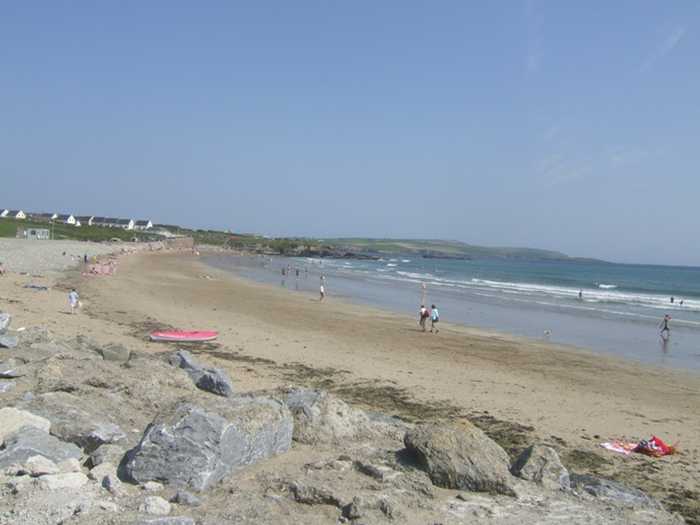
Garretstown is located in the county of Cork. During the bathing season, a lifeguard is on duty. Near the beach, there are toilets and a parking area. Dogs on lead allowed. Guests with impairments can access the beach.
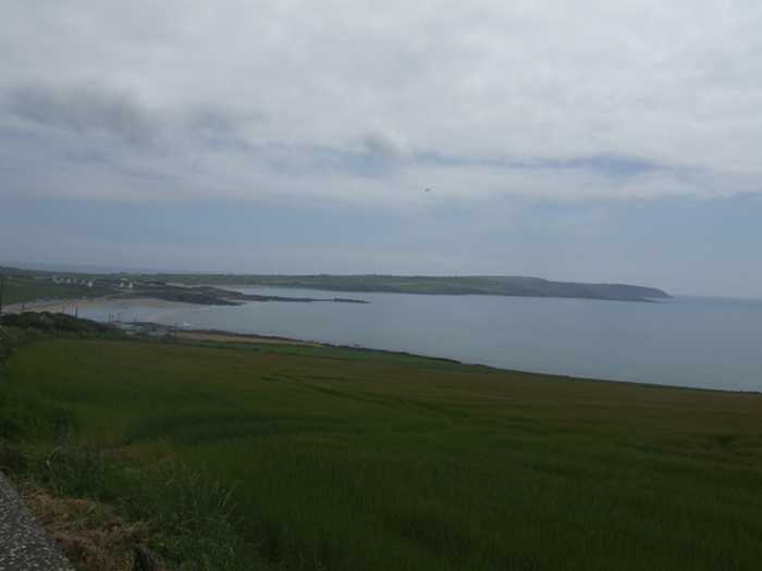
Garrettstown Beach, a sandy beach with gentle slope, faces south and is bordered by rocky cliffs. The beach area is surrounded by Natural Heritage Area, Special Protection Area, and Special Areas of Conservation, though not a part of them. Despite being susceptible to rough weather, the beach draws anglers, walkers, surfers, and windsurfers to the area. Garrettstown Marsh lies north of the beach.
Public car parking is provided at the rear of the beach with paths & steps providing access to the beach. Public toilet facilities are provided adjoining the car park. Life guards are on duty during the bathing season, attendance times are shown on the beach notice boards. The lifeguard station is located at the rear of the beach. The lifeguards provide emergency first aid services. The beach is used to some extent by anglers, walkers, surfers & windsurfers.
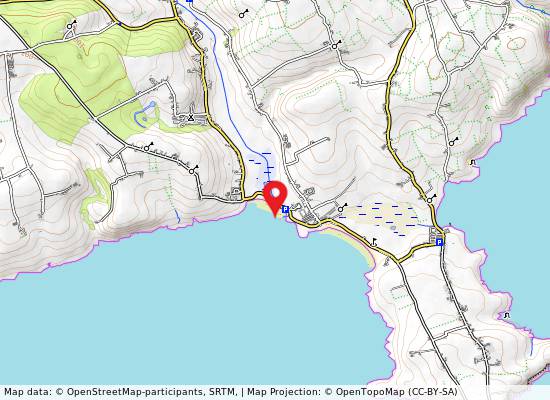
Garrettstown Beach is located approximately 2.5 km south of Ballinspittle village & approximately 8 km south west of Kinsale, inWest Cork. Garrettstown Beach is located in the Courtmacsherry Bay Coastal Water Body (Water Body Code SW_090_0000). The bathing area is approximately 300m wide, & is approx. 0.045km2 in area.
Garrettstown Beach is a sandy beach which is flanked on both sides by rocky cliffs. The beach is a south facing beach & is quite open to rough weather. There are large areas of exposed rock at both ends of the beach. The Ballinspittle River discharges onto the eastern end of the beach through a man-made channel in the rocky cliff.

Weather forecast
Garretstown on the map
Report water temp:

Photos near Garretstown

John M
Photo: John M CC BY-SA 2.0
Do you have a nice picture from Garretstown?
By uploading an image, you certify that you own the image and that it may be displayed on beachguideireland.com

Reviews of Garretstown

No reviews of Garretstown yet...
Please help the next visitor by writing a few lines about the beach, are there toilets? Is it shallow? Is there a jetty or maybe a kiosk?
What do you think of the beach?

Beaches close to Garretstown

Garrylucas, White Strand ⟼ 0.7 km away
Garrylucas beach has a gentle slope and is surrounded by rocky cliffs. It faces southwest and is often exposed to harsh weather and rough seas. Sand dunes and the proposed Garrylucas Marsh Natural Heritage Area (pNHA 000087) are located to the north. The beach is utilized by anglers, walkers, surfers, and windsurfers.
Coolmaine ⟼ 6 km away
Coolmaine Beach is currently closed for all aquatic activities due to dangerous currents resulting from storm damage. The beach is gently sloping and sandy, with a low rocky cliff to the south and rocky outcrops to the north. There are occasional accumulations of sea lettuce from the Argideen/Courtmacsherry Estuary, Garranefeen Strand and Coolmaine Bay. This beach is situated within the Courtmacsherry Bay Special Protection Area, Courtmacsherry Estuary Special Area of Conservation and proposed Natural Heritage Area. Although the beach is utilized by anglers, it is presently unsafe for swimming or any other aquatic activity.
Oysterhaven ⟼ 11.8 km away
Oysterhaven Beach, found in Oysterhaven, Co Cork, is an ideal location for windsurfing, sailing, and kayaking due to its sheltered nature, making it one of Ireland's top spots for water sports.
Rocky Bay ⟼ 19.9 km away
Rocky Bay Beach, situated in Carrigaline, Co Cork is a 300m long, south-facing sandy beach. Access to the beach is through a narrow local road with limited parking available.
Inchydoney East Beach ⟼ 20 km away
Inchydoney East is a south-facing sandy beach with a 500m long bathing area and approximately 0.12km² of water for swimming.
Inchydoney West Beach ⟼ 20.3 km away
Inchydoney West Beach is a south facing, sandy beach located at the north east of Clonakilty Bay. It has gently sloping terrain and is prone to rough weather. The beach is backed by sand dunes and occasionally experiences large accumulations of sea lettuce. Muckruss Strand, a tidal lagoon and sand flats, is situated to the west of the beach. Inchydoney beach is a part of the Clonakilty Bay Special Area of Conservation and is also considered a proposed NHA (site code 000091).
Fountainstown ⟼ 23.6 km away
Fountainstown Beach slopes gently towards the east and consists of sand and shingle. The beach is flanked by a low rocky cliff to the north and rocky outcrops to the south. A concrete wall, along with a car park, borders the beach from the west. Fountainstown Swamp, a proposed Natural Heritage Area, is located north of the beach. The beach is primarily used for windsurfing and fishing.
Red Strand ⟼ 26.2 km away
Red Strand is found near Clonakilty, Co Cork. The beach is sheltered and boasts stunning vistas of Galley Head lighthouse on the adjacent peninsula.
Owenahincha, Little Island Strand ⟼ 29.8 km away
Owenahincha is a gently sloping sandy beach that is backed by sand dunes extending between 70m & 100m. However, it can experience very strong wave action and rip tides or strong currents. A picturesque cliff walk links the Warren Strand to Owenahincha. A Special Area of Conservation, Kilkerran Lake & Castlefreke Dunes (SAC 001061), lies approximately 1km east of the beach. While Owenahincha beach is frequented by limited numbers of surfers, windsurfers, canoeists, and anglers.
Warren, Cregane Strand ⟼ 31.1 km away
Warren Beach is a serene, sandy beach with a gentle slope, facing south east and surrounded by sand dunes that stretch between 40m and 50m. The beach is nestled in a small bay, approximately 500m away from the coast, which offers some protection. The pNHA 001075, Rosscarbery Estuary proposed Natural Heritage Area, flows into Rosscarbery Bay, just southwest of the beach. Although frequented by a small number of surfers, windsurfers, canoeists, and anglers, the beach remains tranquil.
Beach Guide Ireland Source for water samples and information: the Environmental Protection Agency, users of the site and local municipalities.
Source for weather data: Met Éireann© (CC BY 4.0) Disclaimer: Met Éireann does not accept any liability whatsoever for any error or omission in the data, their availability, or for any loss or damage arising from their use.
Source of satellite-read water temperature: Copernicus Sentinel satellite data from the European Space Agency.